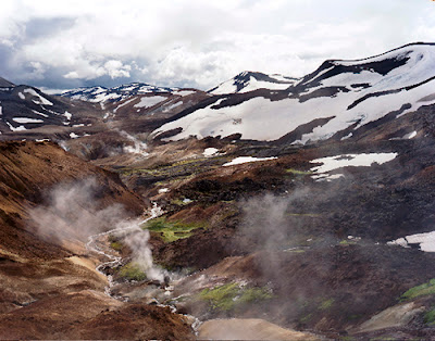
Often called the "Land of Fire and Ice," the country of Iceland is covered 24% by lava fields and glaciers. Formed mostly of a central volcanic plateau surrounded by mountains, South Iceland's physical geography can be impermeable and non-porous with a high drainage density. When water flows over the land not much is absorbed by the pedosphere (soil) in what is known as a weather limited landscape.
| Photograph showing a highly impermeable area of South Iceland. (http://www.esquire.co.uk/2009/10/the-cold-hard-truth/) |
Drainage patterns in Southern Iceland tend to be radial. As rain falls and snow melts it moves down surfaces creating rills and eventually gullies over time. When the water reaches the flat lands, the drainage patterns become dendritic and spread across the surrounding areas.
 |
| Radial drainage patterns flow down surfaces like this mountain range. (http://www.panoramio.com/photo/45762608) |
 |
| Dendridic drainage patterns spread outwards like tree branches. (http://www.onegeology.org/extra/kids/earthprocesses/drainagePatterns.html) |
Unique to glaciated areas is an outwash plain known as a sandur. Made up of silt and sediments deposited by meltwater from glaciers, sandar form as glaciers slowly erode the rocks beneath them. The water quickly travels to the broad plains leaving large deposits along the way. Sandar sometimes look like rivers or tributaries but are distict in composition.
 |
| Skafourwash sandur in Iceland. (http://www.visualphotos.com/image/2x4741248/iceland_skafourwash_sandur) |
 |
| These sandar look like rivers. (http://www.hoteledda.is/) |
When more water is on the surface than can be absorbed a process called overland flow occurs. This may result in waterfalls, a type of gravitational water. Due to it's terrain, South Iceland is known for it's abundance of waterfalls and tourism is becoming increasingly popular.
 |
Fluvial topography as a result of overland flow.
(http://www.superstock.com/stock-photos-images/1841R-82291) |
 |
| Skogafoss Waterfall. (http://www.vjv.com/destinations/europe/iceland/geysers-glaciers/images/iceland-skogafoss-waterfall.jpg) |
Only 1% of the total land area of Iceland is under arable cultivation, confining the majority of the population almost exclusively to the outer lowland areas of the country. Flooding following earthquakes and volcanoes can lead to town evacuations with some farms and houses destroyed.
 |
| Flooded farmland in Southern Iceland. (http://www.transitionsabroad.com/listings/travel/articles/iceland-living-under-the-volcano.shtml) |
Sources
