Wednesday, April 11, 2012

The Aurora Borealis

One of the most fascinating sights in South Iceland is the aurora borealis, also known as the Northern Lights. It's counterpart in the southern hemisphere is the aurora australis, aptly called the Southern Lights. For centuries mankind has been fascinated with these brilliant, natural light shows in the earth's upper atmosphere. Named after the Roman goddess of dawn, Aurora, and the Greek name for the northern wind, Boreas, the aurora borealis can best be seen in South Iceland between November and March when periods of darkness last around 20-21 hours a day.
  

Image of the aurora borealis on a cool, clear night in Reykjavik.
The aurora borealis occurs in the ionosphere, an extension of the thermosphere, beginning around 50 km and stretching to more than 1000 km. The ionosphere is distinct because it is ionized by solar radiation from the sun and is comprised of electrically charged atoms and molecules.  

Carried by solar winds traveling around 1 million miles per hour, highly charged particles, including electrons, escaping the sun interact with the earth's magnetic field along with elements in the atmosphere. Earth's magnetic field traps some of these particles and while spiraling back and forth along the magnetic field lines, they travel lower into the atmosphere near the north and south magnetic poles where the magnetic field lines disappear into the body of the Earth.  


View of the aurora borealis from above in this picture taken from space.
 
The delicate colors are caused when energetic electrons collide with oxygen and nitrogen atoms. This excites the electrically charged atoms, and when they decay from these states, they emit the light seen in the auroras. The colors we see depend on the altitude at which they decay as well as which atom is struck. 

Colors of the Auroras

•Green - oxygen, up to 150 miles in altitude
•Red - oxygen, above 150 miles in altitude
•Blue - nitrogen, up to 60 miles in altitude
•Purple/violet - nitrogen, above 60 miles in altitude  

 
This green aurora borealis is known as a streaming aurora and
occurs when a sudden increase in brightness passes
horizontally through the sky
http://www.chilloutpoint.com/featured/stunning-images-and-legends-of-the-northern-lights-aurora-borealis.html
Large, featureless auroras covering the entire sky are known as veils like this rare red aurora borealis.
http://www.art.com/products/p13681766-sa-i2708936/michael-s-quinton-red-aurora-borealis-alaska.htm

Thin beams of bright light that hang almost vertically are called
ray auroras like the ones seen in this picture.


Sometimes auroras appear to be patches in the sky like this purple/violet aurora and may also flash, or pulse.

Closer to earth, oxygen atoms flash a greenish white as oxygen tends to be more "excitable" than other atoms, making this the color most seen in South Iceland. Many people travel to South Iceland to catch a glimpse of this amazing lightshow as clear skies make for a perfect setting. However, not many guided tours are led far from villages due to winter weather and lack of daylight hours.

In South Iceland where so many months are spent in seemingly never ending darkness, the aurora borealis provides those who live there an amazing, natural phenomena directly outside their front doors.


Sources

Wednesday, March 7, 2012

Some Basic Hydrology of South Iceland

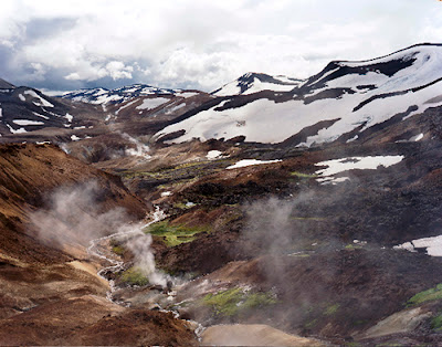
Often called the "Land of Fire and Ice," the country of Iceland is covered 24% by lava fields and glaciers. Formed mostly of a central volcanic plateau surrounded by mountains, South Iceland's physical geography can be impermeable and non-porous with a high drainage density. When water flows over the land not much is absorbed by the pedosphere (soil) in what is known as a weather limited landscape.

Photograph showing a highly impermeable area of South Iceland.
 (http://www.esquire.co.uk/2009/10/the-cold-hard-truth/)

Drainage patterns in Southern Iceland tend to be radial. As rain falls and snow melts it moves down surfaces creating rills and eventually gullies over time. When the water reaches the flat lands, the drainage patterns become dendritic and spread across the surrounding areas.

Radial drainage patterns flow down surfaces like this mountain range.
(http://www.panoramio.com/photo/45762608)
Dendridic drainage patterns spread outwards like tree branches.
 (http://www.onegeology.org/extra/kids/earthprocesses/drainagePatterns.html)

Unique to glaciated areas is an outwash plain known as a sandur. Made up of silt and sediments deposited by meltwater from glaciers, sandar form as glaciers slowly erode the rocks beneath them. The water quickly travels to the broad plains leaving large deposits along the way. Sandar sometimes look like rivers or tributaries but are distict in composition.
 
Skafourwash sandur in Iceland.
(http://www.visualphotos.com/image/2x4741248/iceland_skafourwash_sandur)
 
These sandar look like rivers.
(http://www.hoteledda.is/)

When more water is on the surface than can be absorbed a process called overland flow occurs. This may result in waterfalls, a type of gravitational water. Due to it's terrain, South Iceland is known for it's abundance of waterfalls and tourism is becoming increasingly popular.

 Fluvial topography as a result of overland flow.
(http://www.superstock.com/stock-photos-images/1841R-82291)


Skogafoss Waterfall.
(http://www.vjv.com/destinations/europe/iceland/geysers-glaciers/images/iceland-skogafoss-waterfall.jpg)


Only 1% of the total land area of Iceland is under arable cultivation, confining the majority of the population almost exclusively to the outer lowland areas of the country. Flooding following earthquakes and volcanoes can lead to town evacuations with some farms and houses destroyed. 


Flooded farmland in Southern Iceland.
(http://www.transitionsabroad.com/listings/travel/articles/iceland-living-under-the-volcano.shtml)
Sources

Monday, February 13, 2012

Volcanism In Southern Iceland

Iceland was formed by volcanic eruptions on the Mid-Atlantic ridge (a divergent tectonic plate) about 24 million years ago. (http://waterfire.fas.is/Iceland/Geology.php) As the plates pulled apart from one another, molten rock, or magma, seeped upward as lava and hardened to form new crust on top of the plates.

The Mid-Atlantic ridge; a divergent techtonic plate spreads about 2.5 cm per year. (Red triangles show active volcanoes)
http://en.wikipedia.org/wiki/File:Iceland_Mid-Atlantic_Ridge_Fig16.gif


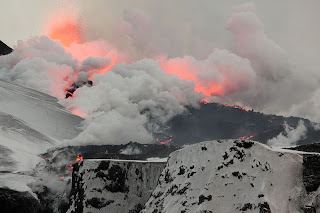
Continuing plate movements, along with the hot spot (a volcanic region beneath the Earth's mantle) under Southern Iceland makes the area high in volcanic activity. The most recent volcanic activity was the eruption of Eyjafjallajokull in early 2010. Eyjafjallajokull is an extrusive composite volcano and until 2010 had been dormant for around 200 years. As seen below, Eyjafjallajokull has the distinct steep sides and large size of a composite volcano.


Photo taken after the eruption of Eyjafjallajokull. Large volumes of ash and gas filled the air for weeks afterwards.
http://public.pwdlabs.com/BlogFiles/2010-04/Jim_Graham_Iceland/2010_04_12_Eyjafjallajoekull_Volcano-0014.jpg


Although a rather small eruption, Eyjafjallajokull caused hundreds of people from nearby villages at the base to be evacuated after shooting tephra and lava into the surrounding air. Caustic, sulphurous gases were the most immediate threat to the people and livestock and no injuries were reported according to medical reports. Over a period of six days, air travel across northern and western Europe slowed to a halt due to large amounts of ash suspended in the atmosphere.  (http://en.wikipedia.org/wiki/2010_eruptions_of_Eyjafjallaj%C3%B6kull)


Fissures (cracks) along the side of  Eyjafjallajokull.
http://en.wikipedia.org/wiki/File:Fimmvorduhals_second_fissure_2010_04_02.JPG

Ash and sulpher compounds in the stratosphere create what is known as "volcanic lavendar" against the setting sun.
http://en.wikipedia.org/wiki/File:Volcanic_Lavender.jpg 

Sources:

Tuesday, January 24, 2012

Introduction


 This is a joint blog for Physical Geography 1202 created by Katie Chapin and Sarah Platts.


  We have chosen South Iceland as our geographical location for the semester. South Iceland is one constituency of six in Iceland. The country is divided this way to ensure fair representation for selecting members of parliament.


  Constituencies of Iceland
 
  We chose South Iceland because we would both love to visit someday due to the unique heritage and breathtaking landscape. South Iceland has amazing waterfalls, volcanoes, and glaciers. It is extremely diverse in it's physical geography and not a country we have learned much about in any other classes.
 
  Over the course of the semester we hope to become knowledgeable in the many forms and processes that have created such untouched landscape in a world so vastly industrialized and populated.


Sunset at Reynisdrangar Cliffs

Images from top to bottom
http://en.wikipedia.org/wiki/South_Iceland